| Our Courses | Creative | Digital Film Making | Web Designing | Programming | Networking | Financial Application | Office Automation | Kids |
|
|||||||||||||||||||||
|
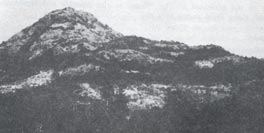
The Sahyadris (or the western ghats) run north to the south, almost parallel to the Arabian Sea.The edge of the deccan plateau and the areas to the east of it are called the Ghats or Desh. The narrow strip of about 40 or 50 km between the sea and the rise of the Sahyadri is known as the Konkan. It is fertile, with rivers cutting through it and it is flat with few hills rising in it's expanse. Bombay lies in the Konkan. Strictly
speaking, these areas do not forma part of the sahyadris. But they are convenient
and easy of approach and have great natural beauty. Most of the places are
good for a drive, family outings and some for rugged climbs. For
the sake of convenience, the region is divided into three regions taking Bombay
as the center. o
Kamandurg (652m-2140ft)
o Tungareshwar (664m-2177ft) This is the highest plateau in this region. It is thickly wooded and is a great delight in the monsoon. From the Vasai station catch a bus to Kaman and get down at tungareshwar phata. After crossing the highway, walk on a cart track which leads to a popular temple of Shiva (3km). Ahead the track climbs up a further 10km to the flat top. On the Northern end of the tungareshwar plateau, giant walla offers rock-climbing opportunities.From the Ahmedbad highways one can reach the bifurcation directly by car or bus.
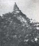
o Asherigad. This little known fort lies on the Bombay-Ahmedabad highway. Reach Manor naka (102km) from Bombay. 10 km ahead is the village Khadkona at the base of the fort. There are two ways to the top, and once you get there a cave, water tanks and a lake (only in the monsoon). Good opportunities for rock climbing.
Course Project at my Institute
|
|
|||||||||||||||||||||||||||||||||||||||||||||||||||||||||||||||||||||||||||
|
||||||||||||||||||||||||||||||||||||||||||||||||||||||||||||||||||||||||||||